
Click on the links below for information on the Points of Interest!
Broughton Hall was officially renamed in 2016 for former Mayor Brenda Broughton in recognition of her efforts in its renovation. It is a hot spot for community activity, from yoga and Tai Chi to Christmas Market and Trivia Nights, there is always something happening. Upstairs is where the Council meets and where the Historical Society has their display. Upgraded to electric-only heat pumps in 2025.
Below the Village Office is the Veterans Memorial Garden, planted in 2020 with commemorative tulips from Holland. For many years, the village has filled Broughton Hall on Remembrance Day with a service that included our youngsters as well as our veterans.
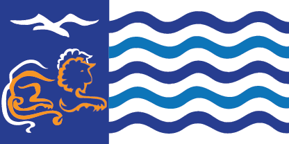
If the wind extends it, you’ll see the design of the Village flag flown with the flags of Canada and British Columbia. It was commissioned in 1996 honoring 25 years of incorporation and designed by Victor Miles, an artist and long time resident of Lions Bay. Can you see why it was chosen as the village flag?
At the end of the path, you’ll find a wooden emblem, ‘The Spirit of Lions Bay’. This was commissioned for the 2010 Olympics held in Vancouver and Whistler. Master Carver Darrel Loppe and his team created it based on original artwork of a local artist, Michael Tickner.
Harvey Creek is the largest of the creeks running through the Village. Not only a source of beauty, along with Magnesia and Alberta Creeks it provides our drinking water, treated and two plants.
You will see Alberta Creek later on this tour and if you choose to venture to Brunswick, you can visit Magnesia Creek and Crystal Falls.
The huge debris catchment basin above was constructed after a devastating debris flow in 1984.
Next to the bridge is ‘Marjorie’s Meadows’. It is one of our in-village off leash areas and offers a delightful path beside Harvey Creek up to the basin.
Botanical artist, Mary Comber Miles conceived the idea of a native plant garden in 2010. It exhibits over thirty native plants and was created with the desire to highlight the diversity and beauty of local plant life. It is now maintained by local gardeners, endorsed and supported by Council. If you like, this is an opportunity to smell the roses. You may take some time to view Mary’s art, read the signs and wander the pathways.
Early in the 1900s this small area of Howe Sound was cleared by loggers opening space for settlers to arrive. By 1911 the first cottages were built by Brunswick Beach and in the 1920’s St Mark’s Church summer camp began on Lions Bay Beach. Both sites remained a summer retreat, accessible only by boat. Imagine living here without electricity, telephone or running water! When the railway arrived in 1954 and the highway in 1958, utilities soon followed, and people began to live here permanently.
Bob Nelson, the first developer, sold lots here in the 1950’s, built a beach house and wading pool to attract residents. Lions Bay Marina opened in 1965 and remains under the care of the original family.
For many years, the community has enjoyed the beach as a local gathering place. In the summer winter storm drift logs are removed and a float is installed. There’s a Dip&Dash Polar Bear Swim January 1st, fireworks July 1st and Firefighters’ Fundraiser in September. Today you will meet both residents and visitors who have discovered our beach.
Take a walk along Lions Bay Avenue to the next signpost. You could call this street ‘Mayor’s Main Street’. Since the village was incorporated on January 2, 1971, Mayors Stewart, Pollock, Broughton, Wyman and Berry have lived here.
On a clear day there is a stunning view of what we call ‘The Lions’ from this vantage point. Long before settlers named them for a supposed resemblance to the lions statues in London's Trafalgar Square, indigenous people have called them ‘The Two Sisters’ for an old Coast Salish legend. The audio recording will offer you their message of peace and sisterhood, and that there is always something to be learnt from the land.
The earliest recorded ascent of The Lions is 1889 when Chief Joe Capilano escorted H. O. Bell-Irving to the summit. He wrote that they followed a herd of wild goats to the peak of the western Lion. Now a difficult but accessible trail leads the way to the summits. In 1996 for the 25th Anniversary of the village, a group of residents hiked to the summit with the new village flag.
Lions Bay is a true community that celebrates together but also suffers and cares for each other in times of need.
During the night of February 11, 1983, a debris torrent on Alberta Creek swept away the home of Mike and Pat Wade, which was on this site. Their two sons, David and Tom, were buried and tragically did not survive. The Lions Bay community was devastated. Volunteers arrived to assist the rescue teams and the community surrounded and supported the family.
On June 16th, 1996, The David and Tom Wade Memorial Park was dedicated in their memory.
- David Michael Wade, March 21, 1963--February 11, 1983
- Stephen Thomas Wade, March 22, 1964--February 11, 1983
Since 1971 the village has been served by the General Store and Cafe. The mailroom arrived a year later. Over the years our ‘commercial centre’ has seen a variety of merchants. Currently we seek to meet the needs of both residents and visitors with a café and general store that highlights local artisans. Sometimes on a warm evening you’ll find an outdoor concert happening.
Perhaps this is a time for cold or warm drink, rest in the patio!
We have many trails in Lions Bay, all lovingly built and maintained by a group of dedicated residents. You’ll find them on all on your map. When the highway was being widened to four lanes prior to the Olympics, it gave our group of volunteer trailblazers a wonderful opportunity to connect Brunswick Beach to the main village.
On May 14th 2011, the Centennial Trail was officially opened with a ceremony in the village hall, followed by over 150 people hiking to the Brunswick Beach overpass to enjoy a huge BBQ. We chose to call it the Centennial Trail because it was exactly 100 years since the first cottagers arrived at Brunswick Beach.
If you look at the trail map you can see most of the 20 km of trails built over the last twenty years.
Along this trail you’ll find some interesting nature identification signs. Perhaps you want to take a moment to learn about our natural world.
From this vantage point, as you look across Howe Sound, you can see to your right, Anvil Island, straight ahead is Gambier Island, the small island to the left is Bowyer, and beyond is Bowen Island. The mountains behind Gambier are on the mainland and head west to the Sunshine Coast. The lights of Gibson’s shine at night and you can often see the ferries that sail between Horseshoe Bay and Langdale.
Since time immemorial, the Átl’ka7tsem/ Howe Sound inlet and adjacent mountains and valleys have been the traditional territory of the Skwxwú7mesh Úxwumixw (Squamish Nation), and these lands remain unceded to this day.
The Squamish were a travelling people. They paddled up and down the Sound, along the rivers and inlets, and to the islands. One name for paddling up the sound Átl’ka7tsem pronounced At-Kat-sum - and the other name for paddling down, Texwnewets’ , pronounced Chock-Now-it.
The first Europeans to arrive were the Spanish in 1791 and they were followed the next year by the British. It is Captain George Vancouver’s choice of naming it after Admiral Earl Howe of the British Navy that has remained with us. Most of the sites along the Sound were named by Captain Vancouver or Captain George Richards after officers or ships in the British Navy: Gambier Island/Chá7elkwnech was named for Captain James Gambier; Bowen Island/Nexwlélexwm is Master James Bowen; Keats/Lhek'̱tines/ is Sir Richard Keats; Brunswick Beach is HMS Brunswick; Bowyer/Lhákw’tich is Admiral George Bowyer.
Anvil Island/Lhaxwm was named by Captain Vancouver who was inspired by its shape. There is boat access only with a summer church camp and a few summer cottages on it. Historically it has been one of the many cultural sites for the indigenous. See the Squamish Atlas for more. http://squamishatlas.com/
The rough rocks that you see just south of Anvil are Pam Rocks. They are recognized protected bird breeding sites and a great place to view seals sunning themselves. Pam Rocks is a reporting weather station for the marine weather system. Winter northerly gales can reach close to hurricane force here.
If you look straight ahead, over the top of the electrical pole you might catch a glimpse of an eagle’s nest on the edge of the fir tree! They often return to raise a family there.
After decades of industrial development and pollution, a public outcry in the 1980s led to environmental reforms and, over the past decade, a stunning recovery of marine life. The return of whales and dolphins to the inlet, and the discovery of internationally significant glass sponge reefs by citizen and government scientists, has swelled public pride and inspired further conservation and scientific efforts. In September 2021, Átl’ka7tsem/Howe Sound, an area renowned for its rich Indigenous culture, biodiversity and distinct geography, became Canada’s 19th UNESCO Biosphere Region, www.howesoundbri.org.
If you want a longer walk, there is an option to continue to Brunswick Beach and enjoy the local stream, and beachfront community, otherwise, finish this loop, turning right on the main trail and then turn up the hill on Loggers Lane towards the school.
April 2, 1977 was an exciting day! The village was lively with families and now at last, there was a school right here in Lions Bay.
Nestled in the coastal forest above Howe Sound, Lions Bay School provides a learning environment like no other. Students are given the unique opportunity to become globally conscious and locally active citizens through inquiry, environmental education, and place-based learning. Over seen by a Vice Principal in charge and supportive staff, our multi-aged classrooms foster leadership and social-emotional learning. Students thrive in a setting that encourages them to become independent learners who build their education on a foundation of compassion, collaboration, and critical thinking.
Currently the school offers before and after school care and Pre-school to Grade 3.
Living in the forest and removed from the city, the residents knew they needed emergency services so in the 1970’s they organized the Lions Bay Volunteer Fire Department and purchased their own fire engine. Later they formed a volunteer Ambulance Crew and outfitted a station wagon to be an ambulance. Over the years the residents have warmly welcomed many changes into their emergency services.
Now the Klatt Building, named for Dale Klatt and his dedication to the community, is a special resource for our village. It is home to three essential services:
- Lions Bay Fire Rescue has approximately thirty-five paid, on call Firefighters. The department responds to all emergencies including medical, fire, motor vehicle accidents and public service. They have even been known to deliver babies.
- The BC Ambulance Service is the other primary tenant of the Klatt Building with up to 4 paramedics on duty at any given time, serving Lions Bay and the North Shore-Sea to Sky area.
- Lions Bay Search and Rescue began as a local volunteer initiative and now operates under the umbrella of the Provincial Emergency Program. The team provides wilderness and urban search and rescue services, primarily in the area from Horseshoe Bay to Porteau Cove. They will also assist teams in nearby regions as well as participating in disaster relief efforts across the province. Listen for helicopters overhead. They could well be our team providing an essential search and rescue service.
- Emergency Support Services is also housed here. This is a team of Lions Bay volunteers who are trained to respond in a time of a natural disaster to assist those needing emergency food, clothing and shelter.
Allow 30-60 minutes to enjoy the walk to Kelvin Grove which will take you past the Public Works, community garden, to the dog beach and back through the neighbourhood and Pride Trail to Lions Bay Beach.
The trail begins below the bridge and then beside the highway. On your right you’ll see Frank Smith Works Yard which is responsible for the operations and maintenance of all village assets including parks, beaches, roads, bridges, drainage, water and sewer networks. It is named in honor of Frank Smith who for nearly thirty years cared for the infrastructure of the village. We now have seven full-time employees that work hard to keep our village a safe, well-functioning and beautiful place to live. We’re proud of our high-quality drinking water too – fresh from the mountains and maintained by this crew!
Kelvin Grove was developed in the 1980’s and formed the second area within the village. Follow your map to find your way through Kelvin Grove to the community gardens. They were first built in 2011 and rebuilt in 2021 to encourage a knowledge of food awareness and organic gardening methods. You’ll find the dog beach just down the path. There is usually a lot of fun there.
Follow the map to find your way through a different route of Kelvin Grove to the Pride Trail which will take you to the parking lot above Lions Bay Beach and Marina.
Allow 60 minutes to continue along The Centennial Trail to Brunswick Beach, Crystal Falls and back onto The Centennial Trail.
Brunswick is the oldest part of Lions Bay and joined the village in 1999 to become the third area. First surveyed in 1908 the properties were sold for $1 down, $1 per week for a total price of $100-$250 and first cottages were built in 1911. A self-sustaining community soon developed.
When you come to the end of The Centennial Trail there is a thoughtful commemorative plaque, then turn left, head down the hill, under the bridge and across the tracks. If you turn right, there you can explore Magnesia Creek as it arrives at the ocean or turn left and walk through the quiet community to the beach. On the way back up the hill the map will lead you to Crystal Falls before re-joining the trail to the school.